Bidadi Twin-Betta Loop
Bidadi → Byramangala backwaters → Narasimhaswamy Betta (fort-hill trek) → Kanakapura → Gavi Ranganatha Betta (cave temple, mud track to the top) → Kanva reservoir → Ramanagara → Manchanabele backwaters → Bidadi. ~140 km of village roads, two hill temples, two dirt sections.
A one-day loop out of Bidadi that strings together two little-visited hill temples south of Bangalore — Shri Narasimhaswamy Betta, a fort hill above Vadedoddi with stone steps and ruined ramparts, and Gavi Ranganatha (Gaviranga) Betta near Singarajapura, where the shrine sits in a cave behind a pond and a mud track climbs the hill. Between them the route deliberately stays off the Mysore highway: reservoir bund roads at Byramangala and Kanva, the granite-boulder country around Ramanagara, and a finish through the Manchanabele backwaters where the tarmac gives out into dirt. Short enough to start at 6 AM and be home for dinner, with about two hours of walking.
Route idea: Instagram location tag — Narasimha Swamy Hill Temple, Bidadi & Gavi — the two pins that started this; the loop around them is my own
The route
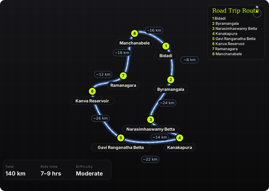
Schematic map generated from waypoint coordinates — the shape follows the geography (compressed so long legs don't squash the loop), distances are labelled per leg. Not a navigation map. Download the graphic.
Leg by leg
| # | Leg | Dist | Notes |
|---|---|---|---|
| 1 | Bidadi → Byramangala Bidadi – Byramangala road | 8 km | Leave the highway immediately. Narrow road along the Byramangala reservoir bund — pelicans and painted storks in winter, best at first light. tarmac |
| 2 | Byramangala → Narasimhaswamy Betta Byramangala → Kanchugaranahalli → village roads to Vadedoddi | 24 km | Single-lane village roads through ragi fields and eucalyptus. Navigate by map to 'Shri Narasimhaswamy Betta'; the last km is a concrete road behind an arch, often locked — park outside and walk. narrow tarmac / concrete |
| 3 | Narasimhaswamy Betta → Kanakapura Vadedoddi – Kanakapura | 14 km | Back to a proper road. Kanakapura is the fuel and lunch stop — the only real town on the loop. tarmac |
| 4 | Kanakapura → Gavi Ranganatha Betta Kanakapura – Channapatna road, turn for Haniyuru / Singarajapura | 22 km | Rolling farmland with granite outcrops. Mud road up the hill to the temple; a stone-step trail if you'd rather walk it. tarmac, then mud track |
| 5 | Gavi Ranganatha Betta → Kanva Reservoir Haniyuru → Channapatna → Kanva dam road | 26 km | Channapatna (toy town) is the only busy bit. Turn off for Kanva — quiet bund road along the reservoir with hills all round. tarmac |
| 6 | Kanva Reservoir → Ramanagara Kanva – Ramanagara | 12 km | Into the boulder country that Sholay was shot in. Ramadevara Betta is a short detour if daylight allows (closes 5:30 PM). tarmac |
| 7 | Ramanagara → Manchanabele Ramanagara – Manchanabele road | 18 km | Broken village road, then the dam. Dirt tracks around the backwaters — the loop's proper off-road section. broken tarmac / dirt |
| 8 | Manchanabele → Bidadi Manchanabele – Bidadi | 16 km | Quiet run back to Bidadi through farmland, past the Big Banyan Tree turn-off. tarmac |
Highlights
- Shri Narasimhaswamy Betta — an hour's climb up ancient stone steps past overgrown fort walls to a small temple and pool on top; almost nobody but villagers goes.
- Gavi Ranganatha Betta — Rishyashringa's cave shrine behind a pond, Bhairaveshwara temple alongside, and a 360° view over Mari Betta, SRS hills and the lake below.
- Byramangala and Kanva reservoirs — two bund roads that most riders skip, both empty at dawn.
- Ramanagara's granite boulders on the Kanva road — Sholay country without the Sholay traffic.
- Manchanabele backwaters at sunset — dirt tracks down to the water with Savandurga on the skyline.
Off-road & motorcycling notes
Mostly single-lane village tarmac with two genuine dirt sections: the mud track up Gavi Ranganatha Betta and the backwater trails at Manchanabele. Both are fine on an ADV or scrambler in the dry; on a road bike walk the hill and stop at the dam.
- Gavi Ranganatha mud road: loose red soil and rock steps; rideable in dry months, slick as soap after rain. Low tyre pressures help.
- Manchanabele backwater tracks: soft sand near the water's edge, ruts from 4x4s. Turn around before the ground goes dark and wet — bikes sink.
- Narasimhaswamy Betta: no riding above the arch. The trek is 30–60 min up with loose soil on the descent — proper shoes, not riding boots.
- Village roads near Vadedoddi: unmarked speed breakers, cattle, and sudden gravel patches where the surface has been dug up.
- Carry a tyre-plug kit; there is nothing between Kanakapura and Ramanagara.
Timings, permits & fuel
- Gavi Ranganatha cave shrine is opened only on Saturdays and festival days — ride it on a Saturday if you want to go inside; the hill and outer temple are open daily (roughly till 6 PM).
- Narasimhaswamy Betta temple opens around 8 AM; the gate road may be locked — park outside and walk.
- Ramadevara Betta closes at 5:30 PM. Manchanabele dam area is best left before dark; no lighting.
- Fuel: Bidadi at the start, Kanakapura mid-loop, Ramanagara near the end. Locals near Narasimhaswamy Betta sell bottled petrol in a pinch.
- No permits. Both hill temples are free; small parking fee at Gavi Ranganatha.
Cautions
- Gavi Ranganatha's hill is surrounded by forest — bears visit the artificial pond. Don't linger after dusk, don't leave food out.
- The Narasimhaswamy Betta pool is polluted by offerings; carry your own water for the trek.
- Monsoon (Jun–Aug) makes both dirt sections unrideable and the stone steps slippery; the reservoirs are prettiest right after, in Sep–Oct.
- Google Maps will try to put you back on the Mysore highway between Channapatna and Bidadi — ignore it and follow the Kanva/Ramanagara/Manchanabele legs.
Along the way

Wikimedia Commons · free licence, see file page

Wikimedia Commons · free licence, see file page

Wikimedia Commons · free licence, see file page

Wikimedia Commons · free licence, see file page

Wikimedia Commons · free licence, see file page

Wikimedia Commons · free licence, see file page

Wikimedia Commons · free licence, see file page