Nelliyampathy & Munnar Back-Door Loop
Bangalore → Coimbatore → Palakkad → Nenmara → Pothundi dam → Nelliyampathy → Pollachi → Udumalpet → Chinnar → Marayoor → Munnar → Anachal glass bridge → Bodimettu ghat → Theni → Dindigul → Salem → Bangalore. ~1,260 km over four days, entering and leaving Munnar by its two quiet roads.
Two Kerala hill stations from the reels, joined by the roads nobody uses. Nelliyampathy first — the underrated one, a 15 km ghat above Pothundi dam that ends at the Seetharkundu cliff and the forest department's jeep tracks. Then instead of the Kochi highway, Munnar from the back: Udumalpet through Chinnar sanctuary to Marayoor's sandalwood forest and up the Kanthalloor side. The Anachal glass bridge — shut on its opening day in Dec 2025 and reopened by court order in July 2026 — is 12 km out of Munnar; after it, the reel says, 'the real thrill begins': the steep estate road below Anachal. Leave Munnar east over the Bodimettu ghat into Tamil Nadu and run home through Theni and Dindigul.
Route idea: @sherry_thegirlnextdoor (Nelliyampathy) & @the_pretty_escape.travel (Munnar glass bridge) on Instagram — two reels; the back roads between them are the point of this loop
The route
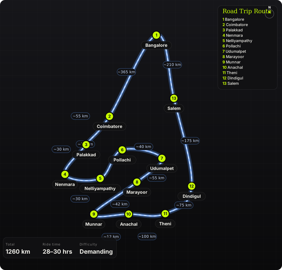
Schematic map generated from waypoint coordinates — the shape follows the geography (compressed so long legs don't squash the loop), distances are labelled per leg. Not a navigation map. Download the graphic.
Leg by leg
| # | Leg | Dist | Notes |
|---|---|---|---|
| 1 | Bangalore → Coimbatore NH 44 → Salem → NH 544 → Coimbatore | 365 km | Day 1: the highway day. Six lanes all the way; Coimbatore for the night. tarmac |
| 2 | Coimbatore → Palakkad Coimbatore – Walayar – Palakkad (NH 544) | 55 km | Day 2. Through the Palakkad gap into Kerala. tarmac |
| 3 | Palakkad → Nenmara Palakkad – Nenmara | 30 km | Nenmara is the last town: fuel and food — nothing past here on the hill. tarmac |
| 4 | Nenmara → Nelliyampathy Nenmara → Pothundi dam → Nelliyampathy ghat | 30 km | 15 km of ghat with 10-plus hairpins through forest, then estates to the top. Seetharkundu viewpoint is a short path off the road; Kaikatty forest IB books the jeep tracks. 12 hairpins tarmac, narrow |
| 5 | Nelliyampathy → Pollachi Nelliyampathy → Nenmara → Kollengode → Pollachi | 75 km | Back down and across the state line on the quiet Kollengode road. Night 2 in Pollachi. tarmac |
| 6 | Pollachi → Udumalpet Pollachi – Udumalpet | 40 km | Day 3. Flat, coconut country. tarmac |
| 7 | Udumalpet → Marayoor Udumalpet → Amaravathi → Chinnar sanctuary → Marayoor | 55 km | The back door: a forest road through Chinnar Wildlife Sanctuary (check post, daytime only), then Marayoor's sandalwood reserve and Kanthalloor's orchards. tarmac, narrow |
| 8 | Marayoor → Munnar Marayoor – Munnar via Kanthalloor side | 42 km | Climb through Eravikulam's fringe to Munnar. Night 3 in Munnar. tarmac |
| 9 | Munnar → Anachal Munnar – Anachal (Chithirapuram road) | 12 km | Day 4. The glass bridge is at Kanachery above Anachal — 35 m long, 40 people at a time. The estate road below it is the steep, tight bit from the reel. tarmac, steep |
| 10 | Anachal → Theni Anachal → Munnar → Bodimettu ghat → Bodinayakanur → Theni | 100 km | Out the east side: the Bodimettu ghat drops from 1,500 m to the Tamil Nadu plains in 30 km of forest hairpins — Munnar's best-kept road. tarmac |
| 11 | Theni → Dindigul Theni – Dindigul | 75 km | Plains again. Dindigul for lunch. tarmac |
| 12 | Dindigul → Salem Dindigul – Karur – Salem (NH 44 / NH 544) | 175 km | Highway. tarmac |
| 13 | Salem → Bangalore Salem – Krishnagiri – Bangalore (NH 44) | 210 km | Home; 425 km on day 4, so start Anachal early. tarmac |
Highlights
- Seetharkundu — the cliff-edge viewpoint at Nelliyampathy, 1,000 ft straight down to the Palakkad plains, usually with a waterfall in view.
- Nelliyampathy's forest jeep tracks to Mampara — wild elephants at dawn, bookable at Kaikatty (₹50 entry + jeep).
- The Chinnar–Marayoor road — dry-forest sanctuary, sandalwood, and the megalithic dolmens above Marayoor.
- The Anachal glass bridge — and, more to the point, the estate road below it.
- Bodimettu ghat — Munnar's quiet eastern exit, hairpins through shola forest to the plains with almost no tourist traffic.
Off-road & motorcycling notes
Tarmac throughout, but three of the legs are narrow forest or estate roads where surface and wildlife matter more than speed. Any bike handles it; an ADV is more comfortable on the broken Nelliyampathy and Marayoor stretches.
- Nelliyampathy ghat: narrow, with monsoon-broken edges and no railings at the falls. No fuel or food on the hill — Nenmara is the last.
- Chinnar sanctuary road: single lane, elephants and gaur; check post allows daytime only. Don't stop for photos where there's no shoulder.
- Anachal estate road: steep enough that the reel's commenters 'smell clutch plates' — first gear, and check the brakes before the descent.
- Bodimettu ghat: cold and foggy early morning; the Tamil Nadu side has broken patches and truck traffic near Bodi.
- Leech socks in the bag if any of it is within a month of the monsoon.
Timings, permits & fuel
- Pothundi dam: 8 AM – 6 PM, ₹10. Kaikatty Forest IB (jeep tracks, Mampara): 7 AM – 3 PM; ₹50 forest entry, jeeps ₹1,200–2,000.
- Seetharkundu viewpoint: 6 AM – 6 PM, free.
- Chinnar Wildlife Sanctuary road (Udumalpet–Marayoor): daytime crossing only; check-post timings roughly 6 AM – 6 PM.
- Anachal glass bridge reopened July 2026 after a court order; hours and price change — check before relying on it.
- Fuel: Coimbatore, Palakkad, Nenmara, Pollachi, Udumalpet, Marayoor, Munnar, Bodinayakanur, Theni. Fill at Nenmara and at Udumalpet.
- Stays: Coimbatore (night 1), Pollachi or Nelliyampathy estate bungalows (night 2), Munnar (night 3).
Cautions
- Nelliyampathy is best avoided Jun–Aug (landslides, closed jeep tracks). Munnar is fine in monsoon but the Anachal road isn't.
- The glass bridge was built on disputed land and closed once already — treat it as a bonus, not the reason for the trip.
- Wild elephants: Chinnar, the Marayoor–Munnar road at dusk, and the Bodimettu ghat. Give way, engine off.
- Four long days; the Bangalore–Coimbatore and Dindigul–Bangalore legs are 365 and 425 km of highway — don't stack them with the hill days.
Along the way

Wikimedia Commons · free licence, see file page

Wikimedia Commons · free licence, see file page

Wikimedia Commons · free licence, see file page

Wikimedia Commons · free licence, see file page

Wikimedia Commons · free licence, see file page

Wikimedia Commons · free licence, see file page

Wikimedia Commons · free licence, see file page