Kolli Hills — 70 Hairpins
Bangalore → Krishnagiri → Salem → Rasipuram → Karavalli → 70 continuous hairpins to Semmedu → Agaya Gangai falls → Namakkal → Dharmapuri → Bangalore. ~620 km over two days to the 'Mountain of Death'.
Kolli Malai in the Eastern Ghats is named for Kolli Paavai, the goddess said to guard the hill with an unforgiving hand — and the ghat road from Karavalli is her handiwork: 70 numbered hairpins in 27 km, stacked on top of each other so tightly the drone shots look fake. On top it's a different world: jackfruit and coffee, the Arapaleeswarar temple, and Agaya Gangai, a 300-foot fall reached by a thousand steps down (and back up). Out via Salem, back via Namakkal so you ride the hairpins once each way and never repeat road.
Route idea: @walterwhite007 on Instagram — 'Feeling brave? Kolli Hills, Tamil Nadu — also called The Mountain of Death'
The route
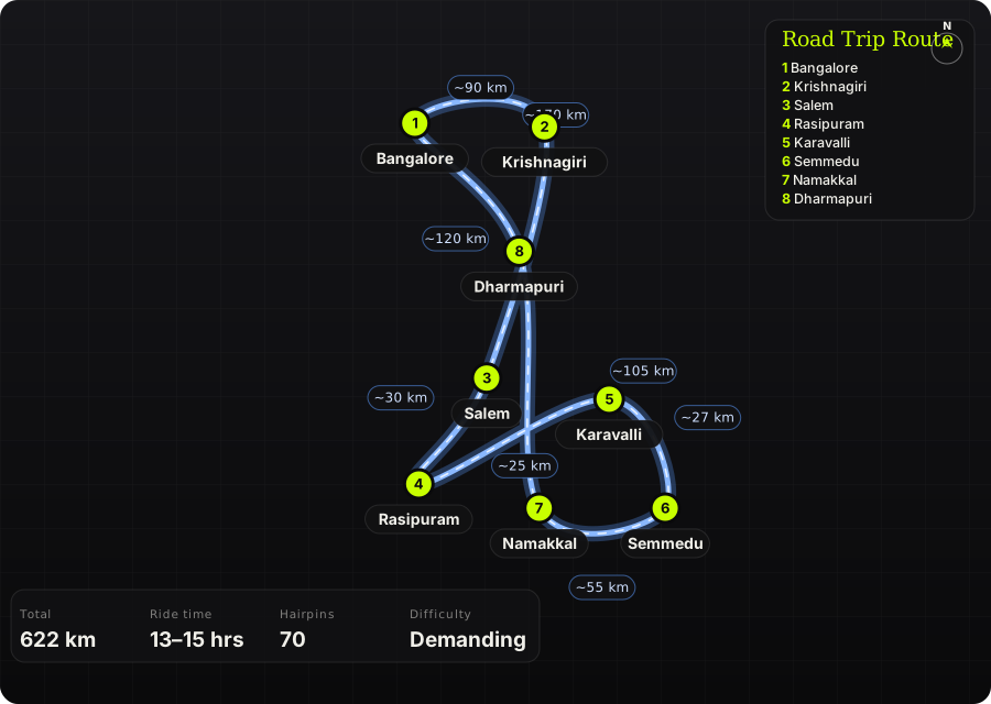
Schematic map generated from waypoint coordinates — the shape follows the geography (compressed so long legs don't squash the loop), distances are labelled per leg. Not a navigation map. Download the graphic.
Leg by leg
| # | Leg | Dist | Notes |
|---|---|---|---|
| 1 | Bangalore → Krishnagiri NH 44 via Hosur to Krishnagiri | 90 km | Day 1. Six-lane; leave by 5 AM to clear Hosur before the trucks. tarmac |
| 2 | Krishnagiri → Salem NH 44 Krishnagiri – Dharmapuri – Salem | 120 km | Fast and dull; breakfast at Dharmapuri. Fuel in Salem. tarmac |
| 3 | Salem → Rasipuram Salem – Rasipuram (NH 44 / SH) | 30 km | Silk-weaving town; last proper shops before the hill. tarmac |
| 4 | Rasipuram → Karavalli Rasipuram → Sendamangalam → Karavalli | 25 km | Two-lane through paddy to the base of the ghat. Top up here — nothing on the climb. tarmac |
| 5 | Karavalli → Semmedu Karavalli – Semmedu ghat road | 27 km | The 70 hairpins, numbered on stone markers. Bends 15, 21, 35, 52 and 66 are the tight, blind ones. 40–60 minutes if you don't stop; you will stop. 70 hairpins tarmac |
| 6 | Semmedu → Namakkal Semmedu → Arapaleeswarar temple → Agaya Gangai → down the Senthamangalam side → Namakkal | 55 km | Day 2. Falls are a 1,000-step descent from the temple car park — budget two hours. The Namakkal-side descent is gentler and the road down is better surfaced. tarmac |
| 7 | Namakkal → Dharmapuri Namakkal – Salem – Dharmapuri (NH 44) | 105 km | Namakkal fort and the Anjaneyar statue if you want a stop; otherwise the highway north. tarmac |
| 8 | Dharmapuri → Bangalore Dharmapuri – Krishnagiri – Hosur – Bangalore | 170 km | Home. Hosur toll traffic after 5 PM is the last obstacle. tarmac |
Highlights
- The Karavalli ghat — 70 hairpins in 27 km, the densest sequence of bends in South India, with the plains dropping away behind every third turn.
- Agaya Gangai — a 300 ft waterfall in a gorge below the Arapaleeswarar temple; the thousand steps back up are the real workout of the trip.
- Seekuparai and Selur Nadu viewpoints — the plateau's edge, 1,000 m straight down to the Namakkal plains.
- Vasalurpatty boat house and the Semmedu botanical garden for the lazy afternoon in between.
- Namakkal fort on the way home — a hill fort on a single rock in the middle of the town.
Off-road & motorcycling notes
All tarmac, but the ghat is the point. Seventy hairpins on a road that buses, tempo travellers and coffee lorries share; the riding challenge is line discipline, not surface.
- Hairpins are tight enough that a bus takes the entire road — stop before the apex if you hear a horn, don't try to squeeze.
- Gravel washes onto the inside line at the numbered bends after rain; brake before, not in, the corner.
- Fog sits on the top 20 hairpins in the early morning Nov–Jan — headlight on, visibility can drop to 20 m.
- Descending the same road is harder than climbing it: engine braking, second gear, and rest the brakes at the viewpoints.
- Agaya Gangai steps are steep and wet — trainers in the bag; riding boots will hurt.
Timings, permits & fuel
- Arapaleeswarar temple: 6 AM – 12 PM and 4 – 7 PM. Agaya Gangai path is open 24 hours but do the steps only in daylight.
- Boat house 6 AM – 6 PM (₹5, life jackets mandatory). Botanical garden 8 AM – 8 PM (₹20).
- No permits or ghat closures; the road is open at night but fog and unlit bends make that a bad idea.
- Fuel: Salem, Rasipuram, Sendamangalam, Semmedu (one pump on top), Namakkal. Fill at Rasipuram before the climb.
- Stay: TTDC and homestays around Semmedu and Solakadu; book ahead in Dec–Jan.
Cautions
- The 'Mountain of Death' name is folklore, but the accident record on the ghat is real — mostly overtaking on blind bends. Don't.
- Monsoon (Jun–Aug) brings landslides on the Karavalli side; the road has been closed for weeks at a time.
- Namakkal-side road (Senthamangalam) is the easier descent if you're tired on day 2.
- Day 1 is 290 km plus the ghat; don't attempt it as a one-day return — it has been done, and it's the riders who do that who end up in the folklore.
Along the way

Wikimedia Commons · free licence, see file page

Wikimedia Commons · free licence, see file page

Wikimedia Commons · free licence, see file page

Wikimedia Commons · free licence, see file page

Wikimedia Commons · free licence, see file page