Kailasagiri Cave Temple & Kaiwara
Bangalore → Hoskote → H Cross → Kaiwara (Bheema-Bakasura Betta, 500 steps) → Kailasagiri hand-cut cave temple → Chintamani → Devanahalli → Bangalore. ~180 km, a half-day loop east of the city.
The easy one in the collection: a Sunday loop east of Bangalore built around Kailasagiri, a hill outside Chintamani where a cave has been cut by hand into the rock and lined with shrines — Vallabha Ganapati, Chaturmukhalingeshwara and Jagadambe — reached by a short stone-paved walk you do barefoot. Pair it with Kaiwara, 7 km away, where the Bheema-Bakasura Betta climb (about 500 steps) earns a view over the Kolar plains. Go out on the Hoskote–H Cross road and come back through Devanahalli so you never repeat tarmac.
Route idea: @the_pretty_indian & @gopravasa on Instagram — '50 km from Bengaluru — a cave temple, a hilltop view'; it's nearer 75 km, but the point stands
The route
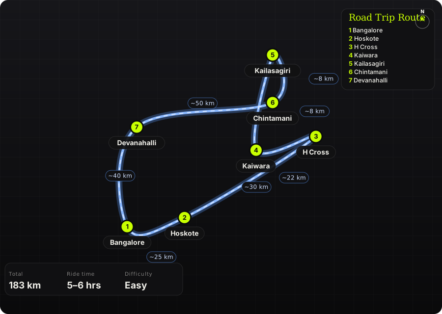
Schematic map generated from waypoint coordinates — the shape follows the geography (compressed so long legs don't squash the loop), distances are labelled per leg. Not a navigation map. Download the graphic.
Leg by leg
| # | Leg | Dist | Notes |
|---|---|---|---|
| 1 | Bangalore → Hoskote Old Madras Road (NH 75) to Hoskote | 25 km | The only dull bit; get it done before the traffic wakes up. tarmac |
| 2 | Hoskote → H Cross Hoskote – Sidlaghatta road to H Cross | 30 km | Two-lane state road through mulberry and grape country; watch for tractors and silk-cocoon lorries. tarmac |
| 3 | H Cross → Kaiwara H Cross – Kaiwara road | 22 km | Quiet rural road. Kaiwara is the Yogi Narayana ashram town; the Bheema-Bakasura Betta steps start behind it. tarmac |
| 4 | Kaiwara → Kailasagiri Kaiwara – Kailasagiri | 8 km | Short hop through the hills. Park at the base; the cave is a 10-minute walk up a stone path, barefoot. tarmac / stone path |
| 5 | Kailasagiri → Chintamani Kailasagiri – Chintamani | 8 km | Lunch stop. Chintamani has proper fuel and food. tarmac |
| 6 | Chintamani → Devanahalli Chintamani – Sidlaghatta – Devanahalli | 50 km | The return leg on a different road: open plateau, windmills on the ridges, very little traffic. tarmac |
| 7 | Devanahalli → Bangalore Devanahalli – Bangalore (NH 44) | 40 km | Fast airport highway home. tarmac |
Highlights
- Kailasagiri's hand-cut cave — a low, cool tunnel through the rock with shrines set into the walls, unlike any other temple this close to the city.
- Bheema-Bakasura Betta at Kaiwara — 500 steps to a rock summit with the Kolar plains laid out below; do it first, before the sun is up properly.
- The Chintamani–Devanahalli plateau road — empty, straight, and lined with wind turbines.
Off-road & motorcycling notes
Tarmac end to end. This is a road-bike loop; the only 'trail' is the stone path at Kailasagiri and the steps at Kaiwara.
- The stone path at Kailasagiri gets hot by midday — footwear comes off at the base, so carry socks or go early.
- Rural roads have unmarked speed breakers at every village; hold 60 and look ahead.
- Kaiwara's steps are steep and uneven; not one for riding boots.
Timings, permits & fuel
- Kailasagiri cave temple is open through the day; go before 10 AM for cool stone and empty paths.
- No permits or fees beyond small parking charges.
- Fuel: Hoskote, Chintamani, Devanahalli — no gaps to worry about.
Cautions
- Weekend crowds at Kaiwara ashram around festivals; the hill itself stays quiet.
- The Hoskote stretch of NH 75 has heavy truck traffic — the earlier the better.
Along the way

Wikimedia Commons · free licence, see file page

Wikimedia Commons · free licence, see file page

Wikimedia Commons · free licence, see file page